
 My name is Nancy Leek. I live in Chico, California and am a retired librarian. I have worked in public, school and academic libraries, including reference librarian for the Butte County Library and children’s librarian at the Orland Free Library. I am the author of John Bidwell: The Adventurous Life of a California Pioneer, and the co-editor (with John Rudderow) of The Miner Poet: The Poems of Pres Longley.
In 2015 I started a series of picture book biographies for young readers called Golden State Biographies. So far the series includes John and Annie Bidwell: The Long and the Short of It and Nancy Kelsey Comes over the Mountain. These books have full-color illustrations throughout by the talented Steve Ferchaud. They are colorful, exciting, and fun to read, and I have received enthusiastic feedback from California schoolchildren.
All books are available by contacting me at goldfieldsbooksca@gmail.com.
I am available for presentations to any kind of group, including 4th grade classes studying California history. I thoroughly enjoy talking with students and will gladly present in your classroom at no charge if you are in my local area (Butte, Glenn and Tehama Counties).
 I also have a program called A Conversation with Major John Bidwell, in which I play a lady reporter in 1858 interviewing Bidwell, who is played by talented actor Nick Anderson. We have presented this program to groups such as Rotary, SIRS, and the Chico Museum. Let me know if you would like to have us visit your group.
I call this blog goldfields because I love Northern California wildflowers and Northern California history. Goldfields is a wildflower that we enjoy seeing every year on Table Mountain here in Butte County, and the goldfields were the attraction that drew so many men and women to the Golden State. Now that I am self-publishing my books, my imprint is Goldfields Books.
At my home in Chico I have a little family orchard, a large vegetable garden, and a crazy flock of chickens. When not writing, I sew and volunteer at the library and at Bidwell Mansion. I also sit on the steering committee of the Association for Northern California Historical Research and assist in publishing ANCHR’s yearly book on local history.
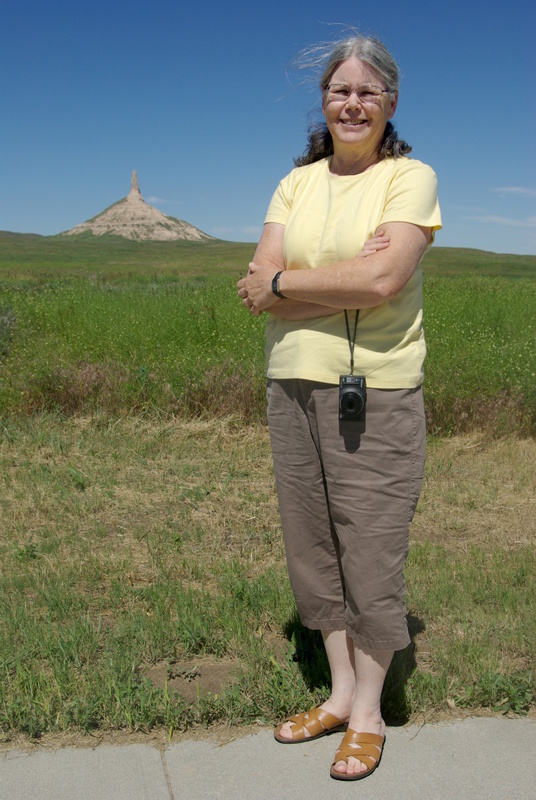
At Chimney Rock, Nebraska, 2014
When my husband Jim and I retired from our jobs in the spring of 2014, we went on a road trip to Wisconsin to visit family. One of my goals on the road was to see some of the sights that the pioneers like John Bidwell and the thousands who followed him would see along the way: Chimney Rock, Scott’s Bluff, Fort Laramie, Independence Rock, the Great Salt Lake and the Humboldt River. Here I am at Chimney Rock in Nebraska.


Hi Nancy, my name is Tyler Ash.
Over the last few years I have been bitten by the Butte County history bug and I just recently discovered your blog. I love it! I was thinking about starting a John BIdwell blog but it seems you already beat me to it! I was a student of Byron Wolfe at Chico State and was taught the art of re-photography. I don’t know if you’ve heard of either but I actually did an independent study on rephotographing some of Chico’s historic photos before I graduated. If you’re interested you can view them at my blog,( tylerashresume.wordpress.com). It will be under the Photography tab. I also wrote an in depth article on the George Crosette House in Chico and another article on the history of Chico’s Cold War missile base. Those are on there as well.
I love learning more and more of the saga of John Bidwell and I will most definitely need to buy your book and add it to my growing collection of Chico history. I’m so glad I stumbled upon your blog because I think it will be my favorite one for many years to come. Hopefully our paths will cross sometime in the future.
Sincerely,
Tyler Ash
Hi Tyler– Thanks for your comment. I haven’t been doing much with this blog lately, but I have good intentions. Your comments are a push in the right direction.
Great photos on your website. I find the idea of rephotography very intriguing, and I’ve always admired Byron Wolfe’s work. My daughter is friends with his wife, and their kids are friends.
You can get my book from Lyon books or from the Visitor’s Center at Bidwell Mansion. I hope we’ll run into each other one of these days. –Nancy
I found your blog super interesting. I love the history of north California too.Good luck!!!
I am interested in the street named SO-WIL-LEN-NO. I understand that it is a Maidu Woman’s name. Annie liked the name and named the street. Is this close to the facts??? Was this woman someone special in John and Annie’s lives???
The street is named after Maggie Sowilleno Lafonso — Sowilleno being Maggie’s Indian name. She was a member of the Mechoopda tribe. Maggie was a favorite of Annie Bidwell. She and her brother Elmer frequently dined at the Mansion, and Maggie was Annie’s greatest helper at the Indian Church. I am not quite sure when the street was named, but probably after Maggie died in 1909. That would make a good topic for my blog! Thanks for asking the question.
Thank you so much Nancy. I have been looking all over for this answer. I look forward to reading more on your blog.
Hi Nancy,
I heard you speak at the Chico Museum and enjoyed it very much. I wonder if you would give your talk at the Newcomers luncheon. The talks are to help newcomers to learn about the area they have moved to .
We provide lunch for you and you would speak for about 30 minutes .
We need a speaker for November 17th. If you are able to do this please get in contact with me. If you are unable to attend the November luncheon, perhaps next year January 26th, March 25?
Thank you,
Donna Gangemi 343-1015
Hi Nancy
I am a volunteer with the National Park Service archeology department. They have a newsletter indicating new “excavations” each summer that one can sign up for. Most are out of California but this one struck me:
“Fort Bidwell was established in 1864 to help protect settlers in Surprise Valley. It was supplied by Fort Crook, established in the 1850s, in the Fall River Valley over 100 miles to the west. The first supply road was the Lassen Emigrant Trail, established in 1848. In 1867, the military constructed an engineered “Military Road” to facilitate delivery of supplies via an easier route. This route was subsequently utilized by settlers who abandoned portions of the rougher Lassen Trail. The road was plotted on the General Land Office survey plats in the early 1870s and was used up to the very early 1900s. Forest Service roads later replaced the military road, which, after the passage of time, has been largely lost to history.”
They will be looking for and mapping the original military road.
Did John Bidwell play a part in this road or fort?
Hi Sandy– Fort Bidwell was named after John Bidwell, but other than that I don’t know much. But I know someone who might, and I’ll ask.
Hi Nancy, you have a wonderful website. Would you consider a guest post? I have published 5 books on California history, mostly about the Sacramento area. Check out my website “California’s Olden Golden Days” at https://cherylannestapp.com/
Hi Cheryl– I’d love to have you do a guest post. I’m out of town right now and not thinking about the blog, but we can get together next week. I’ve seen your webpage and I read your stagecoach book. It would be fun to get to know you better.
Nancy,
A friend of mine and myself are researching Peter Lassen and his death. I was wondering if we could exchange some ideas. Do you know much about William Weatherlow? I cant seem to find much about him After Issac Roop dies. do you know where i can find more information on this Edward Clapper? who was he and why was he with Peter Lassen? ( outside of prospecting with him) Are there any accounts from the native perspective other than Cheif Winnemucca saying Pete was the best man hes known?
Hello Charles– If you can solve the mystery of Peter Lassen’s death, you’ll make California history. All my information comes from biographies of Lassen. Ken Johnston’s book on the Lassen Trail, Legendary Truths, has thorough coverage of Lassen’s death. You can find more about Weatherlow at findagrave.com — https://www.findagrave.com/memorial/22611488/william-weatherlow He died in 1864.
Edward Clapper’s bones were dug up years later and brought back to Susanville. The Lassen Historical Museum in Susanville has a picture of a reconstruction of his face. The museum also has files on Peter Lassen. These are all things you can check out if you haven’t already. I don’t have any other sources than that. Good luck!
Hello Nancy, this is Sue Cejner-Moyers from Yuba Couty, I present a tlak or tour every 1st Saturday and would love for you to join us and share your books, blog, website and all that you have done. Let me know if you would be interested in sharing.
Hi Sue– I’d love to come and do something with you and your group. Tell me more or contact me at goldfieldsbooksca@gmail.com.
Hello Nancy,
I’m helping my 9 year old daughter research a very distant relative of ours for her 4th grade project about California pioneers. Her name was Bridget Miranda Evoy and she led a wagon train to California in 1849. We’ve been piecing together her story from a combo of family lore and google searches. I’m reaching out because your site pops up with a few tidbits from her life. I’m wondering if you have any more information to share?
Thank you,
Jessie
Dear Jessie– Send me an email at goldfieldsbooksca@gmail.com and I’ll see if I can put you in touch with Craig Harwood, another relative of the remarkable Bridget Evoy. He knows much more about the family than I do.
Dear Nancy,
I am a Chico native who moved away from Chico after my eighth grade in 1954.
Although I didn’t go to high school in Chico, I still attend class reunions of my grammar school class in Chico.
At an entertainment affair held for a reunion several years ago, I met a Chico High School graduate who knew many of my classmates, and we maintained email correspondence for a couple of years. She had an abiding interest in Chico history, and followed your history blog.
She forwarded two questions to me, concerning an old photo of a bridge, evidently on the occasion of a major dedication as the group included John Bidwell and his wife, President Rutherford B. Hayes and his wife, and General William T. Sherman.
The questions were: (1) what bridge was it; and (2) which of the men in the group was General Sherman.
The first question was easy enough: President Hayes went on a countrywide tour in 1882, and visited Chico and the Bidwells in Chico on that trip. Sherman was friends with Bidwell and joined the entourage. And 1882 was the year the Chico Free Bridge was built.
The next question was harder. But with some research I learned that Sherman was “a very tall man”. I also noted from civil war photos that his hair at that time was slightly receding primarily on the left side of his head. In the bridge photo, one gentleman stood in the back and all you can see was his head from chin up, as he was standing directly behind a woman. The woman herself appeared to be about the same height as the ofher women, but like all the other women wore a tall hat. So that head behind her had to be attached to a very tall man. When I examined the photo carefully with a magnifier I could see the now more-receeded hairline, still more on the left side.
So that was that!
However, I could not determine where the Chico Free Bridge – which washed away in a flood in 1889 – had been located. That question went unanswered for me for more than ten years.
From the beginning I had a photo seen online through the Meriam Library that was labeled “Chico Free Bridge”. But that bridge, as judged by nearby tree heights, could only have been about 100 feet in length and so could not have crossed the Sacramento River (requiring more like 400 feet), which the Chico Free Bridge did. Also there was no indication of its location.
All my off-and-on online searching at the library left me without an answer so I determined I needed to get to the library. But on those few occasions when I visited Chico I found the library closed for some school break or another.
At last, in May of this year I was able to get an appointment in person with a historical collections librarian at the library and finally got my answer. He had collected a pile of documents and some screen images that stated where the bridge was built and showed what it looked like from river views. For some reason I was not allowed to take copies of any of that information away from the meeting, but nonetheless I was happy at last to get my answer!
The bridge was located near the site of a sugar beet processing plant in then Colusa County (that location is now in Glenn County), across the river from Chico Landing. The map coordinates there are:
39.7132022, -121.9463620
This is near the “Capay unit parking lot” on the west side of the river. River Road runs along the river on the east side.
The location was chosen via economic strong-arm: the clout of the sugar beet industry prevailed!
As to the photo labeled “Chico Free Bridge”, that may have been part of the project. If you go from Chico out River Road, you must cross Chico Crreek (which is not wide) and Mud Creek where the two join. Mud Creek is often dry but it’s quite wide, about 100 feet. It must be an estuary, filled with water when the river is running high. To get to the Chico Free Bridge, the only bridge then to cross the river itself in that area, there would have had to be that second, smaller bridge.
Regards,
Larry Nevin
Los Altos, California
Dear Larry– I am impressed with your diligent research. Good sleuthing!
I think you are right with your answers to both questions. The bridge in the photo can’t be the Chico Free Bridge over the Sacramento River, because that wasn’t built until 1882. Pres. Hayes visited in September, 1880.
So I think this is a bridge over Chico Creek near the Sac River. I can’t find any mention of it in Bidwell’s diary or the newspaper though. I don’t know why the only photo we have of that visit to Chico was taken on the bridge.
As for General Sherman, I do think that is him directing behind the lady, who I assume is his daughter Rachel, who accompanied him on the trip. Here is a link to another photo that shows them together on the trip. https://csl.primo.exlibrisgroup.com/view/delivery/01CSL_INST/12135871090005115
I wish he had stepped out from behind his daughter!
If you would like to correspond more about these questions, please email me at goldfieldsbooksca@gmail.com. It’s always fun to talk about history.
Nancy
Nancy,
You are correct about the date. I think I knew that long ago but it slipped away as the date of the Chico Free Bridge emerged. I always thought that the structure of the bridge seen above the group photo was inadequate for a bridge long enough to cross the river, so the photo was taken not on the river crossing bridge. I still think the photo was taken on the bridge over Chico Creek/Mud Creek, which means it was built earlier.
I have a class reunion coming up in mid-September, and plan to visit the sites of both bridges. Sort of a “Mission Accomplished”!
A very side note: one of my classmates is Betsy Meriam Leverenz, the daughter of the man for whom the Meriam Library is named. She and I have not been in touch for decades, but I’m told she’ll be attending the upcoming reunion and I will have a chance to talk to her about these histories. Through longtime friends in Durham, I know that she had a big role in establishing a library at Durham School and served as a beloved librarian to the kids there for many years.
Larry Nevin
Nancy,
If tall General Sherman is standing behind his daughtef with only his head showing above her tall hat, then I think we can assume the Great Civil War Hero is doing a bit of clowning!
Larry
Nancy,
I have recently updated some of my information and conclusions about the Chico Free Bridge, drawing from further inputs from Ryan Brower of the Meriam Library. I have copied the relevant correspondence here for your enjoyment. First, my summary:
Ryan,
Fantastic!
This is all good, and in my mind all settled.
The additional photos and information are very helpful and add considerable corroboration to what you concluded from the earlier information.
I expanded the view of the Chico Free Bridge on my iPad to the maximum the screen resolution would permit, then with a magnifying glass examined the people standing on the bridge. Noting that the roadbed was above the bottom of the bridge truss, and using typical human height for the time, I estimated that the truss height was about 15 feet. Though it’s not easy to determine where the bridge terminates, there are at least 20 truss-heights in bridge length so the bridge was clearly well more than 300 feet long.
I not a bridge expert, but it seems to me the truss and pier arrangement was all that was needed to support the bridge, so the central tower and cables must indicate that it was a drawbridge.
The map is a wonderful confirmation. The position of the “drawbridge” (which term is not really readable on my screen) just upriver on the road that crosses Chico Creek is just right.
The photo of the fisherman at the bridge, clearly the one we’re looking at, with the caption “Chico Free Bridge”, is more icing on the cake.
The 1881 photo of the Bidwells and President Hayes and his wife and others, is something I’ve looked at a lot. The titling confirms that it was taken on the bridge over Chico Creek. The event was during a national tour that the president took near the end of his term of office, and it is known that General William T. Sherman accompanied the president on that trip. I have previously identified General Sherman in the photo, standing at the rear of the group with just his head visible over the tall hat of a woman. He is identifiable because he was known to be a very tall man for the time, and earlier photos showed he had a hairline that was receding predominantly on the left. I was told recently by Nancy Leeks, a historian in Chico who has written books about Bidwell and others, that the woman in front of Sherman was his daughter.
And here was his preceding correspondence:
Hello Larry,
It is nice to hear from you. Let me see if I can break some of this down. The images we are looking at were digitized through a loan from the Bidwell Mansion State Historic Park (https://www.parks.ca.gov/?page_id=460). So, our captions, descriptions, and dates were inscribed on the images or provided by California State Parks.
The image you attached is the same we looked at in person. Here is the link through our digital collections http://archives.csuchico.edu/digital/collection/coll11/id/304/rec/1. I disagree with your size assessment. If you zoom in on the left size of the bridge, you will see folks standing on the deck. Given their size, this bridge was certainly much longer than 100 feet. Bidwell Mansion State Historic Park provided the September 1882 date, which coincides with Chico Free’s opening.
I believe this 1888 map provides the best proof: http://archives.csuchico.edu/digital/collection/coll19/id/567/rec/12. If you zoom on the right side, there is an image of a person fishing, titled “Free Bridge – Sacramento River,” and the bridge is unmistakably the one referenced above.
I know you were unable to access the newspaper articles I previously sent, but there is some information that is relevant. Chico Free had a bridge tender, and the above image is the only I have found with a tender’s shack. Here is a 1882 image of a “Bridge over Sacramento River,” but there is no mention of a location, no proof of a bridge tender, and I do not feel it warrants overriding Bidwell Mansion’s description http://archives.csuchico.edu/digital/collection/coll11/id/297/rec/1. Here is the 1881 image of the Bidwells, Hayes, and Sherman on the “bridge over Big Chico Creek” http://archives.csuchico.edu/digital/collection/coll10/id/227. Comparing this bridge to the one titled, “Chico Free Bridge,” the Chico Free image appears larger and has a different support structure.
Location http://archives.csuchico.edu/digital/collection/coll19/id/113/rec/31. Just east of Chico, there is a “drawbridge” labeled across the Sacramento River. Newspaper articles reference folks coming across Chico Free Bridge from Saint John. They also describe Chico Free as a drawbridge, and this location is the only in the vicinity. Because of this, I am convinced the “drawbridge” is Chico Free. Although the map is dated 1890, it is large and was certainly surveyed over numerous years, without the means to erase the (very many) bridges that were wiped out in the 1880s.
I am still convinced that if you park at the Capay Unit Parking Lot, on the Sacramento’s western bank, and walk directly to the water, this is Chico Free Bridge’s location (given a hundred or so feet to the south).
Happy hunting!
Ryan
Dear Larry– Very interesting — thanks for sharing with me. The only thing I have to contribute is that Meriam Library’s caption on the photo of Hayes, Sherman and Bidwell on the bridge over Big Chico Creek is not quite accurate. Pres. Hayes visited in September 1880, not 1881, and Annie was not present. She was visiting her family in Washington D.C., which sent John Bidwell into a tizzy of anxiety when he learned that the president and entourage would be coming to Chico before she could get home.