October 18, 1841 — A Frightful Prospect

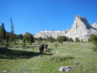
Monday, 18th. Having ascended a about half a mile, a frightful prospect opened before us-–naked mountains whose summits still retained the snows perhaps of a thousand years, for it had withstood the heat of a long dry summer, and ceased to melt for the season. The winds roared–-but in the deep dark gulfs which yawned on every side, profound solitude seemed to reign. We wound along among the peaks in such a manner as to avoid most of the mountains which we had expected to climb–-struck a small stream descending toward the W., on which we encamped, having come 15 miles.

Stunning views, roaring winds, and biting cold. The company is high in the Sierras, but they have crossed the summit; they find a small stream flowing westward. Jimmy John noted: “Today we crossed the main ridge of the mountains of California in the morning about 10 o’clock.” Excellent news! however, they still have a long and difficult descent ahead of them.

Sierra Nevada (or From the Head of Carson River) by Albert Bierstadt

The ascent up a steep pass in the thin air must have been exhausting. Michael Gillis writes:

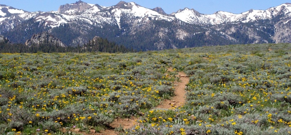
After ascending the last few hundred feet in Golden Canyon, they reached the canyon’s western headwall. At an elevation of 9,425 feet, they crested the Sierra Nevada. In only four days, thanks to good weather, good luck and some savvy scouting, the Bidwell-Bartleson Party had made its way to the west side of the Sierra Nevada.

Their descent takes them down Disaster Creek to where the creek empties into Clark’s Fork of the Stanislaus River. The way down is tough, rocky, and dangerous, but they make it and camp by Clark’s Fork.

This map, from Michael Gillis’s article of “The 1841 Trans-Sierra Route of the Bidwell-Bartleson Party,” is not easy to make out. but if you can spot the little vertical arrow in the middle of the map, that is where they were on October 18th. The solid black line traces their route as far as October 20th, then the two dotted lines are two possible routes after that.

Posted in Bidwell-Bartleson Party | Leave a comment

October 17, 1841 — The Ascent

Sunday, 17th. This morning we set forth into the rolling mountains; in many places it was so steep that all were obliged to take it on foot. Part of the day we travelled through vallies between peaks, where the way was quite level — passed down and up through forests of pine, fir, cedar, &c; many of the pines were 12 ft. in diameter and no less than 200 ft. high. Encamped on the side of the mountain, so elevated that the ice remained all day in the streams — but we had not yet arrived at the summit. Killed another ox this evening — made 12 miles.

Jimmy John gave a similar account, and said, “These forests and fine streams of water have to us a beautiful appearance after traveling so long through an almost entire desert.” According to Michel Gillis, the company followed river drainages as much as possible, rather than attempting to scale mountains.

They began by climbing steeply due west out of Little Antelope Valley . . . up to Rodriguez Flat. From there they dropped down the Snodgrass Creek drainage to Silver King Creek. After a four-and-one-half mile descent along Silver King Creek, they arrived in Silver King Meadows. Heading west across this flat, timbered expanse they intersected the East Fork of the Carson River . . . The trail up the East Fork proved to be relatively flat for the first several miles with some grassy areas available to graze their jaded animals.

“The Trans-Sierra Route of the Bidwell-Bartleson Party”, Overland Journal, Winter 1998.

As they made their way up the East Fork of the Carson, the canyon became more and more narrow, until they branched off into a Golden Canyon, and there camped for the night. The ox they killed for dinner left them with two.

Silver King Meadows http://www.ecoangler.com/habitat/Silver_King_Creek.html

Posted in Bidwell-Bartleson Party, Uncategorized | Leave a comment

October 16, 1841 — The Return of Captain Bartleson

Saturday, 16th. This morning 4 or 5 men started to ascend several of the high peaks to ascertain if it was possible to pass the mountains. Just as they were going to start Capt. B. came up. He was in rather a hungry condition, and had been traveling several days without provision, excepting a few nuts which they had purchased from the Indians and which they had eaten on a very small allowance.

We killed yesterday the best ox we had. This we shared freely with them. There were now but 3 oxen left and they were very poor. But there was no time to lose. The explorers returned & reported that they thought it almost an impracticality to scale the mountains, which continued to increase in height as far as they could see.

This evening the Company was convened for the purpose of deciding by vote whether we should go back to the lake and take a path which we saw leading to the N.W., or undertake to climb the mountains. We had no more provisions than would last us to the lake — nearly all were unanimous against turning back. I should have mentioned that our Indian pilots last night absconded. This stream I shall call Balm river, there being many balm Gilead trees upon it. (It is not laid down on any map.)

So John Bartleson and his companions return, dragging their sorry tails behind them. “They had the commissary with them,” as Dawson relates, meaning the oxen, dinner on the hoof, so they had to catch up and rejoin the company. The renegades told how they had subsisted on pine nuts and fish traded from the Indians. The fish gave them “something akin to cholera morbus”, as Bidwell later said. A bad case of the runs, in other words.

We were glad to see them although they had deserted us. We ran out to meet them and shook hands, and put our frying-pans on and gave them the best supper we could. Captain Bartleson, who when we started from Missouri was a portly man, was reduced to half his former girth. He said, “Boys! If I ever get back to Missouri, I will never leave that country. I would gladly eat out of the troughs with my dogs.” He seemed to be heartily sick of his late experience, but that did not prevent him from leaving us twice after that.

Up into the mountains, or back into the desert? What a dilemma! But they didn’t want to face the desert again, so they chose they mountains, where they hoped to find game. I am not sure which lake he is talking about — he might mean Carson Lake. But then what? They don’t have the knowledge or resources to survive in this harsh landscape like the Paiute. So they chose to press forward.

Time for a nice fall hike in the Eastern Sierra Nevada
Posted in Bidwell-Bartleson Party | Leave a comment

October 15, 1841 — Into the Mountains

Friday, 15th. Advanced upstream about 12 miles and arrived at the base of very high mountains. The creek had become a small spring branch, and took its rise at no great distance in the mountains. But we saw plainly that it was impossible to progress further without scaling the mts., and our Indian guides said they knew no further.

They have reached the base of the Sierra Nevada mountains, a formidable prospect. According to Michael J. Gillis, they are most likely in Little Antelope Valley. They have gone as far as they can go in the valley and now they are going to have to tackle the mountains or turn back.

Mike Gillis, co-author with Mike Magliari of John Bidwell and California, wrote an article for the Overland Journal (Winter 1998) on “The 1841 Trans-Sierra Route of the Bidwell-Bartleson Party.” I’ll be using it to follow John Bidwell across the mountains.

Little Antelope Meadow
Photos from https://jchighcountry.com/little-antelope/

Time for a hike!

Posted in Bidwell-Bartleson Party | Leave a comment

October 14, 1841 — “But We Made No Halt”

Thursday, 14th. This morning we saw at a distance Capt. B. with his 7 men, coming in a direction towards us, but we made no halt, ascended the stream about 20 miles. The mountains continued to increase in height.

That phrase, “but we made no halt” is a telling one. These men (and Nancy, don’t forget her) are not going to wait up for the double-crossing Captain Bartleson and his party. Note that the Kelsey-Bidwell Party is now ahead of Bartleson and his men, even though Bartleson was expecting to reach California before them. What went wrong?

Nicholas “Cheyenne” Dawson was with the Bartleson party, although in his telling some 50 years later, he says the men with Bartleson only meant to do some exploring, not desert the rest of the Company. They seemed to have followed the Walker River downstream until it terminated in a lake. This did not get them where they wanted to go so they headed west. They had eaten up the ration of beef that they had taken with them.

In the meantime Hopper had seen some deer signs; so we camped, and sure enough, Hopper soon killed and brought in a back-tailed deer. We made short work of eating him all up. We also found some baskets of grass seed hidden away by Indians. We confiscated them, poured the seed into the water we had boiled the deer in, and made a delicious soup. While we were devouring the deer, I had noticed Barnett cramming bones into his pocket. I understood this next day when I saw him, as we rode along, gnawing bones.

Traveling the next day we finally struck the river. On the opposite side was a bunch of Indians preparing to leave in haste. By shaking a white rag, we induced them to remain until we approached, for we had nothing left to eat, and thought they might have something we could barter them out of. Although they were frightened at first, we soon gained their good will, and having smoked the pipe of peace with them, let them know by signs our wishes. They produced their stock of trade — a gallon or two of pinion nuts. After tasting these we agreed to take them all, swapping butcher knives for them. We and the Indians then parted, very good friends, each thinking he had the best of the bargain. We now divided the nuts by measure; and I remember that I cogitated for some time — should I make one bait [bite] of mine, or dribble them out. I decided on the latter course, and dropped them into my pocket; but they were delicious.

Pine nuts were a staple of the tribes in the Great Basin. They are high in protein and an excellent food source. For more on the history and culture of pine nuts by Native American tribes in Nevada, go to pinenut.com.

Paiute women harvesting pine nuts in 1912. Courtesy of the Library of Congress.
Posted in Bidwell-Bartleson Party, Uncategorized | Leave a comment

October 13, 1841 — Walker River

Wednesday, 13th. Traveled about 13 miles and only crossed a bend of the river; at this place it ran due north. Day was hot, the creek had dwindled to half its first size.

Jimmy John says it was 25 miles and his figure looks more likely. This was a cutoff to save traveling northward on the river and then back down again. They crossed the creek (the Walker River) and camped on the west side at the foot of a high mountain. This may have been Mount Wilson, in Lyon County, just south of present-day Yerington.

Wilson Canyon, Nevada By Davemeistermoab – https://commons.wikimedia.org/w/index.php?curid=5305377

The trouble with writing about the Walker River and Yerington, is that it starts a song running through my brain, “”Where the Walker runs down to the Carson Valley plain . . .” That’s the first line of Darcy Farrow, a song written by Steve Gillette and Tom Campbell. Probably the most famous version is by John Denver, but the one in my head is this one.

Posted in Bidwell-Bartleson Party | Leave a comment

October 12, 1841

Tuesday, 12th. Traveled about 4 miles upstream, and encamped, understanding our Indian (having hired another pilot) that it would be a long day’s travel to water, after leaving the creek.

Why leave the creek? The creek they are on is the Walker River, which makes a long arc northward and then south. The company plans to leave the river and cut across the hills to rejoin the river further to the west. How they were able to understand this plan from their Indian guide is anyone’s guess.

At any rate, this short 4-mile trek and camp by the river will give their animals time to rest and graze before heading out over waterless terrain.

Posted in Bidwell-Bartleson Party | Leave a comment

October 11, 1841 — Looking for a River

Monday, 11th. Left the lake this morning, going to the mountains on a S.W. course. Today we left the trail of Capt. B. and having traveled 19 miles, arrived on a stream which flowed rapidly, and afforded more water than Mary’s river. We though now, without doubt, that we were safe on the waters of the S. Joaquin (pronounced St. Waukeen) according to Marsh’s letter. Here grew willows, balm Gilead, and a few cottonwoods. The course of the stream as far as we could see was S. — but knew not how soon it might take a turn here in the mountains.

These pioneers had been motivated to set out for California by tales they heard from fur trappers, like Antoine Robidoux, and by letters written by Dr. John Marsh that were published in the Missouri papers. Marsh lived near Mt. Diablo and the nearest large river was the San Joaquin, so the company was on the lookout for it, but they had yet to cross the Sierra Nevada. It gives you an idea how little they knew of the geography around them.

The river they have found was the Walker River, which flows out of the Sierra. This was the river they would follow up into the mountains. In The First Emigrant Train, Bidwell wrote:

Leaving the Sink of the Humboldt, we crossed a considerable stream which must have been the Carson River, and came to another stream, which must have been Walker River, and followed it up to where it came out of the mountains, which proved to be the Sierra Nevada. We did not know the name of the mountains. Neither had these rivers then been named, nor had they been seen by Kit Carson or Joe Walker, for whom they were named, nor were they seen until 1845 by Fremont, who named them.

Bidwell is right about the Carson River, but wrong about the Walker. Joe Walker had explored it in 1833, but it was Fremont who named it.

Bidwell’s “balm Gilead” is either the balsam fir or the balsam poplar. Both trees exude a strong-smelling sweet resin.

Walker River in Nevada
Posted in Bidwell-Bartleson Party, Uncategorized | Leave a comment

October 10, 1841 — Honeydew, Anyone?

[Sunday, 10th] Large numbers of Indians lived about this place, but few (50 or 60) visited our camp. Crossed Mary’s river — it was here running E. leading from the lake which we saw to the W. of us yesterday, into the swamp by which we staid last night. Our course today was S.W. Distance 15 miles — encamped upon the lake.

Fifty or sixty hardly sounds like few to me, but maybe it’s all relative.

On the 7th Bidwell wrote about the “dry cane grass which the Indians had cut in large heaps to procure honey from the honey dew with which it was covered.” The Indians in this region are Paiutes, although Bidwell usually refers to them as Shoshones. Here is a little more about honeydew from his 1877 Dictation.

In the edges of the water the tule was covered with honeydew to an extent that enabled the Indians to gather it in large quantities. They made it into balls about the size of one’s fist and we bought and ate considerable of it. When we afterwards saw them gathering it, we saw that the Indians collected the insects that covered the honeydew as well as the dew itself and formed the whole into a ball.

According to a report titled Native American Plant Resources in the Yucca Mountain Area, Nevada, this reed was Phragmites australis. “The stems of this plant were used to make arrow shafts and wickiup walls. The candy-like,”honey dew’ exudate was scraped off the leaves and eaten as a sugary food.” The honeydew was created by aphids, which were included in the sugary balls. It was undoubtedly a very nutritious food.

Paiute girls with water jugs
Posted in Uncategorized | Leave a comment

October 9, 1841 — Laborious Travel, Nauseous Water

Saturday, 9th. Crossed Mary’s river where it led from the swamp into a lake beyond; our pilot led us south on the trail of Capt. B. Crossed a plain which is covered with water the greater part of the year — then came into sand hills, among which traveling was very laborious. Saw to the W. of us a lake, presenting a sheet of water 20 or 30 miles in extent. Encamped by another swamp, in which the water was very nauseous. Distance 28 miles.

They are traveling through an utter wasteland — no trees, no grass, no good water — just sand hills punctuated by swampy pools of nasty water. They try to follow in the tracks of Bartleson’s men, but the trail was easily lost in the arid soil. In his 1877 Dictation Bidwell says:

Thrown entirely upon our own resources to find our way as best we could through this region and into California, Benjamin Kelsey proved to be our best leader.

So we could call this the Kelsey-Bidwell Party. In the map below, the Humboldt River and Sink are at the upper right. From there the Kelsey-Bidwell Party were guided by the Indian guide southward to Carson Lake, and then westward to the Walker River. This was the river they would follow up into the Sierra Nevada.

Posted in Uncategorized | Leave a comment