“Sunday, 26th. The valley, seen yesterday evening, was but 4 or 5 miles in length and led into another difficult defile, though not so long as the one of yesterday, for we passed it into another valley. Distance 18 miles–-the stream continued to increase in size.”
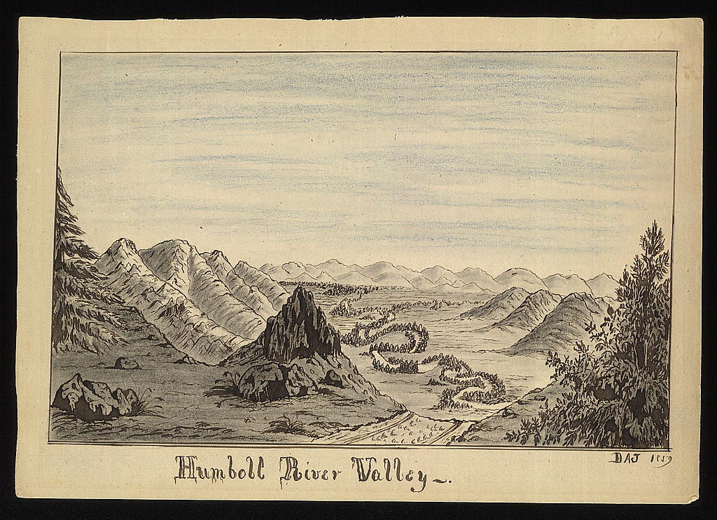
They were by now on Mary’s River, but they didn’t know it. They were still unsure of their position. How do you know you have arrived at the place you have been looking for, when you don’t know what it looks like, and there are no signposts?
In Echoes of the Past Bidwell states that they arrived at the river the day after some men climbed up the precipice and saw a valley a few miles ahead. “By one o’clock that day [we] came out on what is now known as the Humboldt River.” This is looking back from the vantage point of 40 years later, when he knew what he didn’t know back in 1841. At the time, in his journal, the company debates their position for several days before they decide that they are indeed on Mary’s River and headed in the right direction.
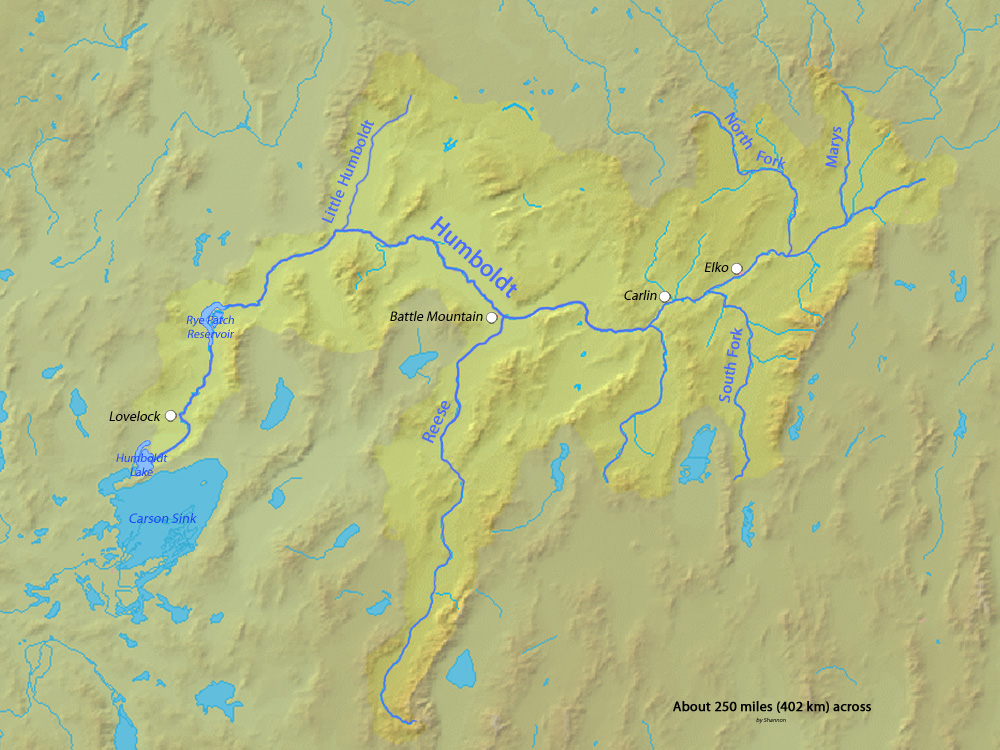
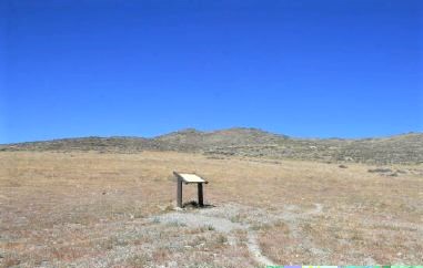
The South Fork joins the Humboldt River about eight miles west of Elko, Nevada. This is also the location today of the California Trail Interpretive Center. If you like trail history, it’s a great little museum to visit, very interactive and family-friendly. Sad to say, it is temporarily closed at this time.
Saturday, 25th. The creek became perfectly dry and its banks rose to high perpendicular precipices, so that there was no other road than the dry bed of the stream. Having come about 15 miles, we encamped in a place affording a little grass and water, where we could see nothing but the sky. But the men who ascended the precipice to see what was in the prospect ahead said that in about a mile we would come to a valley–this was delightful news.
They are in one of the canyons formed by the South Fork of the Humboldt River. It is the end of the summer, so the riverbed is dry. A couple of the men climb to the top of the canyon and come back with good news: there is a valley up ahead.
Here is Bidwell, describing the journey along this stream bed in the 1877 Dictation.
We followed down the stream, but it soon ceased to have any water. This dry streambed we had to cross many times, but at last the banks became so steep that we were confined to the bed of the stream itself. Our animals became very footsore, so much so that they could scarcely stand, yet it was too rocky for them to lie down and the hills were too steep to attempt to get out of the canyon.
We all agreed that it would be impossible for the animals to retrace their steps, as they were much too worn down and jaded. Then came the discussion of the Fort Hall information that if we went too far north we would get into canyons that led into the Columbia River and that we would find it impossible to escape from them. As this canyon had led us in a northerly direction for nearly a day, many became greatly alarmed, believing we had gotten into one of those canyons and would perish there.
Can you imagine the talk going round and round, “Are we too far north? Are we too far south? What did they tell you at Fort Hall? Didn’t they say anything else? What are we going to do? Are we too far north?” and on and on, while they struggle along a rocky creek bed with their starved and miserable animals.
Friday, 24th. As we descended the stream, it rapidly increased in size, and proved to be a branch of a larger stream. The country was desolate and barren, excepting immediately on the streams, where grew a few willows and cottonwoods; the hills in a few places produced a few shrubby cedars. Traveled today about 20 miles.
The creek they were following has joined the South Fork of the Mary’s river. Not that they know that, but at least they have access to water and grass. Numerous small streams flow out of the canyons of the Ruby Mountains join and form the South Fork. The South Fork flows northward, and they want to go west, so they are still wondering when they will be headed in the right direction.
Jimmy John noted in his journal that they killed an ox for food here.
Thursday, 23rd. We could see no termination to the valley, not any signs of Mary’s river. We therefore concluded that we were too far south, and passed over the mountains to the north, where we struck a small stream running towards the N.W. On this we encamped and found plenty of grass, a few fish were caught, some of which were trout, which led us to the conclusion that this was a branch of Mary’s river. Distance 18 miles.
Yay! They have found a creek that will lead them to the south fork of Mary’s River (the Humboldt River). At last they are headed in the right direction. They passed over the Ruby Mountains at Harrison Pass. You can see the South Fork directly below Elko on this map.
Wednesday, 22nd. This morning 80 or 90 Indians were seen coming full speed from the W. Many had horses–one was sent about a half a mile in advance from the rest-–so we ought also to have done, but Capt. B. was perfectly ignorant of Indian customs, and the whole band of savages were suffered to come directly up to us, and almost surround our camp, when Mr. B. Kelsey showed by forcible gestures they would be allowed to proceed no farther. The Indians were well armed with guns and bows and arrows. The only words I recollect hearing Capt. Bartleson say were “let them gratify their curiosity!!”
The Indians were Sheshonees, but like other savages always take the advantage where they can. Besides, they were not a little acquainted with warfare, for they undoubtedly visited the Buffalo Country (having many robes) which requires much bravery to contend with the Blackfeet and Chiennes, who continually guard the buffalo in the region of the Rocky mountains. They traveled as near us as they were allowed, till about noon, when they began to drop off, one by one, and at night there were but 8 or 10 remaining. Distance about 12 miles.
This incident further sunk Bartleson’s reputation in John Bidwell’s eyes. The custom on the plains was for parties meeting for the first time to send out “ambassadors” to check each other out and find out what the other party’s intentions were. Did they want to trade? Did they need help? Or were they looking for trouble? Bartleson, by carelessly ignoring this custom, was endangering the entire company.
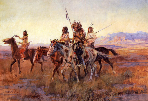
Four Mounted Indians, by Charles Marion Russell
In his 1877 Dictation, Bidwell tells how he and several of the other men “seized our guns and ran toward them, making signs that they must keep off to one side.” He was sure that only a show of force would give them the upper hand and allow them to continue traveling unmolested.
During the day I said to one of the men who messed with [i.e., ate with] Captain Bartleson, “Our captain don’t appear to understand Indian character. If we don’t make those fellows afraid of us, they will certainly attack us. Captain Bartleson is too timid and cautious with them.”
This remark got back to Bartleson, further souring the relationship between the two men.
Nancy Kelsey remembered this incident as well, and particularly her husband’s role in controlling the situation.
At one place the Indians surrounded us, armed with bows and arrows, but my husband leveled his fun at the chief and made him order his Indians out of arrow range.
“The Recollection of Nancy Kelsey” in The Bidwell-Bartleson Party, edited by Doyce B. Nunis
The Indians, as it turned out, were Shoshones, and willing to be friendly, although obviously capable of inflicting damage if they so chose. The Indians offered a dressed buckskin for a handful of ammunition, which they were always in need of. They then rode on either side of the Bidwell-Bartleson Party for several hours, until they gradually dropped off and went their way.
Group of Ute (Shoshone) Indians on the War Path. 1868. Andrew J. Russell, photographer. Imperial collodion glass plate negative. Collection of Oakland Museum of California.
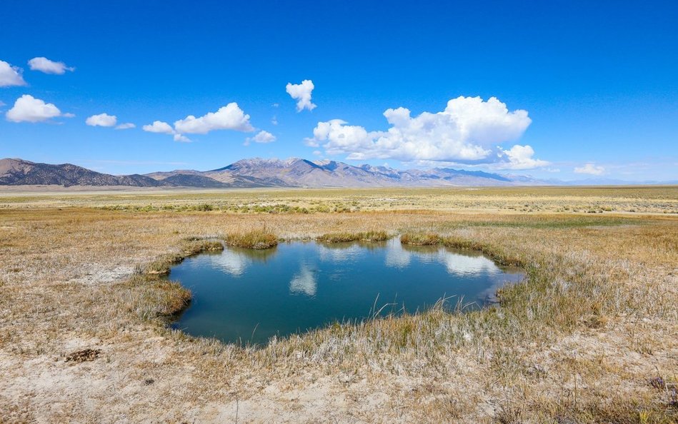
Tuesday, 21st. Hunters returned; many antelope were seen and 2 or 3 killed. About 10 o’clock A.M. as we were coasting along the mountains in a W. direction, we came to some hot springs, which were to me a great curiosity. Within the circumference of a mile there were perhaps 20 springs, the most of which were extremely beautiful, the water being so transparent we could see the smallest thing 20 or 30 feet deep. The rocks which walled the springs, and the beautifully white sediment lodged among them, reflected the sun’s rays in such a manner as to exhibit the most splendid combination of colors, blue, green, red &c. I ever witnessed.
The water in most of them was boiling hot. There was one, however, more beautiful than the rest; it really appeared more like a work of art than nature. It was about 4 feet in diameter, round as a circle, and deeper than we could see–the cavity looked like a well cut in a solid rock, its walls being smooth and perpendicular. Just as I was viewing this curiosity, some hunters came up with some meat. We all partook, putting it into the hot spring, where it cooked perfectly done in 10 minutes—this is no fish story!
The earth around the Springs was white with a substance which tasted strongly of potash, and the water in the springs was of this quality. Traveled about 15 miles. Several Indians came to our camp, several of whom had guns. From signs, this valley contained thousands.
They are traveling along the eastern side of the Ruby Mountains, in a direction more southerly than westerly. Bidwell found these hot springs to be of great scientific interest.
George R. Stewart, in The California Trail, writes: “One sure point is marked by the hot springs which they passed on September 21 and which Bidwell described in some detail. These beautiful springs still bubble out near the base of the Ruby Mountains, just as they did when Bidwell saw them.”
The Ruby Valley Hot Springs can still be visited, but they are in a very remote area, next to the Ruby Mountains Wildlife Refuge and a long way from any services. The water is not “boiling hot,” at least not today, but it gets from 100 to 122 degrees Fahrenheit.
Monday, 20th. Passed along one of the highest mountains we had seen in our whole journey, seeking a place to scale it, as we wished to travel W. instead of S., being convinced that we were already far enough south. At length passed through and descended into a beautiful valley, inclining towards the W. All now felt confident that we were close of the headwaters of Mary’s river — distance 25 miles. Two hunter slept out last night, the Company taking a different direction from that which they expected.
There were indeed already far enough south. The trouble with Nevada is that it is covered with numerous small mountain ranges, all of which run north- south. These create a barrier for anyone trying to travel west. If at this point they had gone north, they would have reached the headwaters of Mary’s River, at Humboldt Wells. That would not have been difficult.
If they could have gone due west, they would have hit the river about where Elko is today. But there were mountains in the way in that direction. Either trip would have been about 25 miles. Instead, they will take a roundabout way, south through the Ruby Valley before turning north. The mountain they see may be Humboldt Peak, the southernmost high summit in the East Humboldt Range.
Sunday, 19th. This morning I met 3 men who were coming to bring me water, etc. Arrived at camp; they journeyed yesterday about 17 miles, did not travel today.
This entry doesn’t tell much. The company is camped at a place called Warm Springs and John Bidwell recuperates there after his ordeal in the desert. He must have been exhausted. He was also quite angry with Captain Bartleson, who had kept the party moving forward after promising to wait for Bidwell. All that will come out in later tellings of the story.
For the rest of the story about finding the oxen and returning to the wagon train, we have to look at other accounts. This is from The First Emigrant Train to California (Echoes of the Past):
They [the Company] had promised to stop when they came to water and wait for me. I traveled all night,and at early dawn came to where there was plenty of water and where the company had taken their dinner the day before, but they had failed to stop for me according to promise.
I was much perplexed, because I had seen many fires in the night, which I took to be Indian fires, so I fastened my oxen to a scraggy willow and began to make circles around to see which way the company had gone. The ground was so hard that the animals had made no impression, which bewildered me. Finally, while making a circle of about three miles away off to the south, I saw two men coming on horseback. In the glare of the mirage, which distorted everything, I could not tell whether they were Indians or white men, but I supposed them to be Indians, feeling sure our party would go west and not south. In a mirage a man on horseback looks as tall as a tree and I could only tell by the motion that they were mounted.
I made a beeline to my oxen, to make breastworks of them. In doing so I came to a small stream resembling running water, into which I urged my horse, whereupon he went down into a quagmire, over head and ears, out of sight. My gun also went under the mire. I got hold of something on the bank, threw out my gun, which was full of mud and water, and holding to the rope attached to my horse, by dint of hard pulling, I succeeded in getting him out — a sorry sight, his ears and eyes full of mud, and his body covered with it. At last, just in time, I was able to move and get behind the oxen. My gun was in no condition to shoot. However, putting dry powder in the pan, I was determined to do my best in case the supposed Indians should come up; but lo! they were two of our party, coming to meet me, bringing water and provisions.
It was a great relief. I felt indignant that they party had not stopped for me–-not the less so when I learned that Captain Bartleson had said, when they started back to find me, that they “would be in better business to go ahead and look for a road.” He had not forgotten certain comments of mine of his qualities as a student of Indian character.
There was no love lost between John Bidwell and John Bartleson. Bidwell, who considered himself a good judge of character and a man of “self-possession,” considered Bartleson to be a hot-headed ignoramus. Bartleson had previously shown himself to be careless of the Company’s safety when approached by unknown Indians.. Moreover, Bartleson would do nothing in the future to distinguish himself.
The two men who came to the rescue were Robert H. Thomes (for whom Thomes Creek in Tehama County is named) and Grove C. Cook. If there was a third man (as he says in his journal entry) it was probably “Cheyenne” Dawson.
Saturday, 18th. Morning found us on the east side of a mountain not far from its base but there were no signs of water; the lost oxen not having come up, I, in company with another young man, went in search of them while the company went on, promising to stop as soon as they found water. I went back about 10 miles, but found nothing of their trail–-the sun was in a melting mood–-the young man became discouraged and in spite of all my entreaties returned to the company.
The young man who went with John Bidwell to search for the oxen was “Cheyenne” Dawson. Under the hot summer sun he gave up, saying that there were plenty of cattle in California. Which was true, but Bidwell had to go on — without his oxen and their packs he had nothing. It is a testament to Bidwell’s character that he carried on alone, determined to find the oxen, even after his friend had given up and turned back.
Water in the company was in very short supply. Before they left on their search they were each given about a half cup (4 oz.) of water. This was all they had until the next day.
About an hour after [Dawson departed] I found the trail of the oxen which bore directly north. After pursuing it some distance, I discovered fresh moccasin tracks upon the trail, and there began to be high grass, which made me mistrust the Indians had got the oxen. But my horse was good and my rifle ready, and I knew the Indians in these parts to be very timid, for they were generally seen in the attitude of flight. But what made me most anxious to find the oxen was the prospect of our wanting them for beef. We had already killed 4 oxen and there were but 13 remaining, including the lost ones, and the Co. was now killing an ox every two or three days.
Having followed the trail about 10 miles directly north, to my great delight I found the oxen. I was soon in motion for the Company, but not being able to overtake them, was obliged to stop about dark. I passed the night rather uncomfortably, having neither fire nor blanket. I knew Indians to be plenty from number signs, and even where I slept, the ground had been dug up that very day for roots. The plains here were almost barren, the hills covered with cedar.
In his 1877 Dictation, Bidwell tells this story again. For those of you interested in firearms, he says that he had “a flintlock rifle and a pair of dragoon pistols also flintlocked.” Before leaving Missouri, he had asked old trappers what kind of weapons to take, and was told to have nothing to do with “those new-fangled things called caps” because if they got wet they were useless, whereas you could always pick up a replacement flint.
Here is a nice little video from the Bureau of Land Management on how to load and fire a flintlock rifle.
Friday, 17th. About 11 a.m. all were ready to start; horses, mules, and 4 oxen, packed. Proceeded south along the mts. seeking a place to pass through. At length an Indian trail took us across into a dry plain, perfectly destitute of grass and water. Traveled ’till about midnight, having come about 17 miles. This plain was white in many places with salt, and the cool evening contrasting with the color of the salt on the ground gave a striking similarity to winter. Two of the oxen that were carrying packs got lost from the Company in the night, about 8 miles from where we encamped, but it was supposed they would follow on.
This is probably the point at which they cross south of the Pilot Range through what today is called Bidwell Pass in Elko County, Nevada. It would be used by some other later emigrant groups, but the California Trail in Nevada generally took a more northerly route. There is a trail marker at the pass.
The lost oxen did not “follow on,” and Bidwell had to go looking for them the next day.