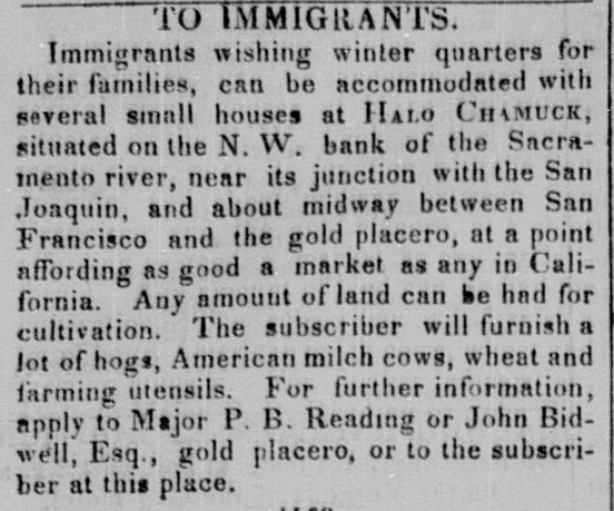
This advertisement appeared in the Californian on September 23, 1848:
IMMIGRANTS. Immigrants wishing winter quarters for their families, can be accommodated with several small houses at HALO CHAMUCK, situated on the N. W. bank of the Sacramento river, near its junction with the San Joaquin, and about midway between San Francisco and the gold placero, at a point affording as good a market as any in California. Any amount of land can be had for cultivation. The subscriber will furnish a lot of hogs, American milch cows, wheat and farming utensils. For further information, apply to Major P. B. Reading or John Bidwell, Esq., gold placero, or to the subscriber at this place.
The item appeared several times in the Californian, signed with the name of the editor, J. D. Hoppe. He also published letters, signed A FRIEND TO ENTERPRIZE and probably written by himself, extolling the virtues of the new settlement on the Sacramento.
So where was this wonder-place that he was promoting, and what did Reading and Bidwell have to do with it?
The future community of Halo Chamuck was located on John Bidwell’s first rancho.
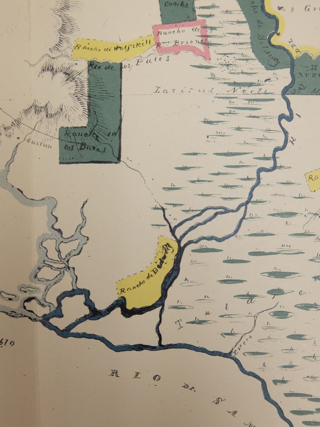
A section of Bidwell’s Mapa del Valle del Sacramento, created for the Land Commission. Rancho de Bidwell (Ulpinos) is colored yellow.
In October 1844 John Bidwell was granted title to Rancho Los Ulpinos by Governor Micheltorena. The grant lay along the northwest banks of the Sacramento River, where the river enters the delta and joins with the San Joaquin River. In January 1846 Bidwell attempted to develop the land and attract immigrants. With the help of Indians he built an adobe house where Cache Slough enters the river. In the fall he managed to attract some immigrants to settle there. The winter of 1846-47 was a harsh one however, and the immigrants suffered from lack of food. According to Rio Vista — History and Development, by Mrs. Duncan S. Robinson:
But the rigors of a severe winter, with lack of adequate food supplies, resulted in the disbanding of both the white and Indian settlers. During the long, hard winter, the hungry and discouraged Indians frequently used the expression “Hale-che-muck”, which meant “nothing to eat”, hence the origin of the name of the Bidwell settlement: Hale-che-muck! !
So Halo Chamuck = “Nothing to eat!” Seems a strange thing to name a town that you want to attract settlers to, but there it is in the newspaper. Did the promoters think that no one would ask what the name meant?
In spite of the harsh winter of 1846-47 driving off the first settlers, Hoppe continued to promote Halo Chamuck (or Halo Chamo, as he sometimes spelled it). In August 28, 1847 he printed a lengthy letter, praising the location:
Amongst the many enterprizes of the day, the laying out of a city on the Sacramento River near its mouth, the proprietors of which are John Bidwell, Esq., Maj. Redding, and Captain J. D. Hoppe, in my opinion is of the greatest importance . . . The said city is to be called Halo Chamo, and is beautifully situated . . . the water deep and the anchorage good . . . especially well adapted for agriculture and grazing . . . many different kinds of timber . . . etc. etc.
Starving winters were not Halo Chamuck’s only drawback. John Bidwell never settled there himself for any length of time. He claimed that the mosquitoes from the nearby tule marshes were so bad that he fell sick from sheer loss of blood. He preferred Butte County’s more salubrious climate.
In 1854 Bidwell’s title to Rancho Los Ulpinos was confirmed by the Board of Land Commissioners. By then he was firmly established at Rancho Chico and he began selling off portions of Rancho Ulpinos. One of the buyers was Col. N. H. Davis, who established a town site not far from the failed town of Halo Chamuck and named it Brazos del Rio, meaning Arms of the River, since it was located where three channels of the Sacramento River come together.
The town was promoted as a way station for steamboats plying the route between Sacramento City and San Francisco. The river teemed with salmon, and a successful salmon fishery was established. All went swimmingly (as it were) until the rains of 1862. The town washed away in the floods.
When the town was reestablished on higher ground, it was renamed Rio Vista, and there it is to this day, where state highway 12 crosses the mighty Sacramento.
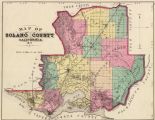
For more on the history of Rio Vista, check out this article on the Solano History website. Click on the map below to go to an 1877 map of Solano County, where you can see Rancho Los Ulpinos and Rio Vista on the lower right.