Mystery Solved!

DSCN3296[1]Back in November 2014 a metal box was discovered in the base of the pioneer monument that sits on the corner of The Esplanade and So-Wil-En-No Ave. A mystery time capsule! What wonders might it hold?

At the time I wrote:

What do you guess might be inside the box? A dry and dusty scroll commemorating the occasion? Pictures by school children? Mementos of John and Annie? A nice big gold nugget?

Don’t we all wish it were John’s first gold nugget or Annie’s Cherokee diamond ring! But it looks like the contents are closer to my first guess: a list of donors. Today the results of the investigation were announced, and you can read about it in the Chico Enterprise-Record. Quoting Ranger Kirk Coon, the article states:

“We are all so excited about what this process revealed,” said Kirk Coon, state parks valley sector supervising ranger, in a press release. “What appeared to be a disintegrated roll of paper turned into pages of readable names of people who donated for the monument. Many school children and other community member’s names are clearly visible.”

Beginning this Saturday you can visit Bidwell Mansion SHP and view the unrolled and carefully preserved contents of the time capsule. Perhaps you will recognize a name. Come take a look and see a bit of Chico history.

Posted in Uncategorized | Leave a comment

A Verse for Leap Year Day

leap2Once upon a time, when the rules of courtship were strict, and a woman could only wait for a man to get a clue and propose marriage, tradition had it that during a leap year a woman could propose to her tardy and reluctant male. According to legend the custom grew up in Ireland, where St. Patrick allowed women this opportunity every four years, after St. Brigid complained to him that the girls were having to wait too long for marriage. Another legend attributes the custom to Scotland, where Queen Margaret decreed that during leap year a maiden could make the first move and snare the man she admired.


There is no evidence for either of these stories, but the tradition of a leap year proposal leap3was a popular legend. It became a humorous trope employed by storytellers, cartoonists (think Al Capp and Sadie Hawkins), and versemakers like Pres Longley. The idea may have faded away in today’s society, but in the 19th and early 20th century it had great currency.

I posted one of Pres’s leap year verses in January. Here is another one.


THE LAST HOUR OF LEAP YEAR
 A youth and a maiden sat closely together,
And passed off the time in discussing the weather.
It was chilly without, but the grate was aglow—
Thomas mildly remarked that he thought we’d have snow.
Susie quickly opposed him in words that were plain,
And thought it most likely we’d have a small rain;
But she soon changed the subject, in tones that were bland,
And placed on his shoulder her little brown hand.

“You know, my dear Tom, ere an hour hath sped,
That this old year will slumber and sleep with the dead,
And before it recedes from my grasp and my sight,
I wish to assume a small feminine right.
Will you marry me, Thomas?” “I declare that is cool.
No, Susie, I can’t. Do you think I’m a fool?”
“You won’t? You’re a brute!” He arose from his chair,
But left in her grasp quite a handful of hair.
                           Pres Longley, 1873    

         leap4
Posted in Pres Longley, Uncategorized | Leave a comment

The Story of So-Wil-Len-No Avenue

I was reminded this afternoon by Sandy Hill that I never followed up on the origin of the name of So-Wil-Len-No Avenue, which she asked about in a comment. The background is interesting, and worth knowing for any Chicoan who enjoys learning about local history.

DSCF0210
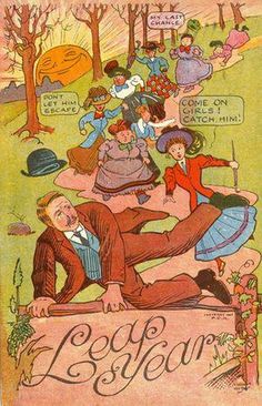
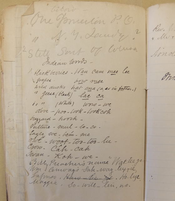
So-Wil-Len-No Ave. runs between Bidwell Mansion State Historic Park and Big Chico Creek, from The Esplanade to Arcadian Ave. There it turns into a campus road, and ends at Tehama Hall. Once upon a time it went further, at least as far as Warner Ave. No structure has an address on So-Wil-Len-No, as far as I know. Google maps spells it Sol-wil-le-no, but what do they know?

It is also sometimes spelled without the hyphens, as Sowillenno Avenue.

The avenue was named by Annie Bidwell for her dear friend, Maggie Lafonso. Maggie’s Indian name, according to Annie’s notebook, was So-will-len-no, as you can see in the image below. This notebook is in the Bancroft Library. Maggie’s name is the last in the list.DSCF0298

Maggie Lafonso was the daughter of Amanda and Holai Lafonso, the Mechoopda rancheria chief. Annie seems to have known that Amanda was the daughter of John Bidwell, a fact considered common knowledge among tribal members today. Maggie was therefore John Bidwell’s grand-daughter and someone whom Annie would have given particular attention and care.

Maggie is frequently mentioned in Annie Bidwell’s diary. She had a lovely singing voice and often sang in the Mechoopda church. She worked together with Annie in establishing the church, teaching and leading worship services. Annie relied on her as a liaison with the Indians on the rancheria and as a co-worker in Christian good works.

On December 21, 1907 Maggie, aged 25, married Joseph Mitchell, an Indian from Colusa. Annie recorded the event in her diary:

Sat., December 21.

Maggie Lafonso married this Evg. Maggie notified me of her intended marriage at 6 this P.M. Invited me to marry her, but I told her it would be illegal. She then said she wished Mr. White if I could not. Young Head took Mr. White & I to village in his automobile to see if they had a license, “yes”.

At 6 P.M. Mr. White & I were at Maggie’s mother’s, where she was married to Mr. Mitchell in parlor. Present: Santa & Amanda Wilson & family. Billy Preacher, Pablo, Hayce, Martha (brides-maid) & others of family. Maggie & Martha dressed in white. Mr. Mitchell & Maggie represented in reverent attitude, at prayer, the figures in the Angelus. I spoke of it to Mr. White who said he had seen it.

Maggie_LaFonso_Mitchell_and_husband_Joe_Mitchell_from_Colusa

Maggie and Joe Mitchell

Sadly, Maggie Lafonso Mitchell passed away after childbirth in 1909. Annie, who had visited her frequently in her illness, was overwhelmed with sorrow at the death of her “beloved Maggie,” and memorialized her in the name of the avenue that ran alongside Bidwell Mansion.


Posted in Uncategorized | 10 Comments

A Little More about Nicolaus Allgeier

I have written before about Nicolaus Allgeier, for whom the town of Nicolaus was named. His first employer in California, John Sutter, assigned him to run a ferry on the Feather River. John Bidwell often stopped at his place in the early 1850s and sometimes assisted Allgeier, who was illiterate, with his business affairs.

In 1884 Hubert Howe Bancroft, or one of his many assistants, wrote to Bidwell and asked about a number of early pioneers. Bidwell wrote back with information — how he had known the men in the early days and what had become of them, to the best of his knowledge. He wrote:

Tonight’s mail brings me yours of the 5th inst. Will try to answer some of your questions: — Nicolaus Altgeir died, but I cannot give the date. He lived on Feather river about one mile below the town of Nicolaus which was named after him. I last saw him in (I think) 1852, and I think he died as late as 1853 or 4 or possibly 5. Henry Brickwedel of San Francisco had charge of his children and property and could probably if living give the exact date of his death.

Bidwell had a phenomenal memory for California history, but he was wrong about Allgeier’s date of death. According to Probate Court records of Sutter County, which can be viewed on Ancestry.com, he died on December 3rd, 1866.

Henry Brickwedel, like Nicolaus Allgeier a native of Germany, did indeed take charge of his children and his estate. Nicolaus had married Maria Stack, a native of Austria. They had at least three children, a boy and two girls. Maria died in 1859. The girls, Ottilia (or Delia) and Mary Augusta, survived their parents.

Nicolaus had cohabited with one or more Indian women before he married Maria, and no doubt he had children from those relationships. There is a Nicolaus Algier listed in the 1885 directory for Yuba, Sutter, Colusa, Butte, and Tehama Counties (also Ancestry.com) Maybe that was one of those children.


Posted in Nicolaus Allgeier, Uncategorized | Leave a comment

Where Is/Was Bidwell Avenue?

DSCF0302-001

A section of the map of the subdivisions of John Bidwell’s Rancho.

Take a look at the section labeled NUMBER 3. It’s at the top of the map. That’s where I live, on Bidwell Ave.

The Bidwell Ave. on this old map runs from Lindo Channel to the County Road (now Bell Road). Today there is another Bidwell Avenue in town which runs along Big Chico Creek west of Nord Ave. (Highway 32.) At one time there must have been two Bidwell Avenues in Chico.

I guess my street lost the coin toss, because it is not called Bidwell Avenue today. I wish it was. It is now Alamo Avenue, between Guynn Ave. on the west and Cussick on the east, although Cussick didn’t make it on to this map.

There are some other interesting things to notice on this section. Grant Ave., to the west of Guynn, is now Nord Ave. The Grange is located where Grant and Rodeo intersect.  But Nord Ave. is also Hwy. 32, which is confusing. Why they didn’t leave that section with the name Grant I have no idea.

On this old map Nord Ave. ends at Lindo Channel, and the road on the other side is Gray Street. When Nord was extended, Gray turned into Nord. East Avenue didn’t even exist.

I suspect that John Bidwell named Gray Street after his orchard manager, George Moses Gray, and Grant Avenue after General Ulysses S. Grant, whom he greatly admired. He probably wouldn’t have cared for the name changes.

I have always wondered if the big old black walnut trees along Alamo Ave. were planted by General Bidwell. I like to think they were, and the fact that this road existed in his day, and was named after him, makes me think they must have been.

Posted in Maps, Uncategorized | 2 Comments

More about the Rancho Chico Map

This map has the name “B. Cussick, Agt” near the bottom. The name helps date the map. So who was B. Cussick?

Bernard Cussick, known as Barney, was born in New York state in 1848. In 1876 he came to California, and after a year in Eureka, he moved to Butte County as foreman with the Sierra Lumber Company. For almost twenty years he managed lumber mills in the mountains at Butte Meadows and at West Branch, becoming Sierra Lumber’s Chico division mountain manager in 1884. He was responsible for a number of innovations and improvements in mill operations and lumber transport. According to Andy Mark, in his book The West Branch Mill of the Sierra Lumber Company, Cussick was the first to use Dolbeer donkey engines and steam hoisting equipment in the region.

In 1895, due to poor health, he left the mountains and the lumber business and came to Chico to pursue a career in real estate.  He laid out and sold several tracts of John Bidwell’s Rancho Chico — the map was undoubtedly part of this promotion. Bidwell mentions meeting with him several times in his diary for 1898. He made for himself a successful second career in banking and real estate. Among his many deals, he was instrumental in promoting the sugar beet industry in Hamilton City.

cussick

Grave marker for Barney Cussick in Chico Cemetery.

Barney Cussick died in 1917. His obituary in the Chico Record called him “a man’s man” and noted that he was “a man of brawn and rugged form, and rugged views of life; a man who fought his way from humble beginnings to a place of wealth and a director of large affairs. With his brawn he had brains, and with both, a heart.”

Barney Cussick’s name lives on as a street name — Cussick Avenue is on the north side of Chico and links Holly Ave. with Bay.


Posted in Barney Cussick, Rancho Chico, Uncategorized | 1 Comment

Rancho Chico Map

On my recent trip to the Bancroft Library I looked at this “Map Showing the Subdivisions of the John Bidwell Rancho,” which is in the Bidwell Family papers there.  I don’t think Meriam Library has a copy of this, or if they do, it hasn’t been digitized. They do have a negative image of one section, titled “Map of the Seventh Subdivision of the John Bidwell Rancho.”

DSCF0301-002

Map of the Subdivisions of Rancho Chico

The map is not dated, although based on the name B. Cussick, I think it is from around 1898. If anyone knows more about this map and when it was made, I’d like to know. Here is a close-up of the title portion:

DSCF0303-001


Posted in Maps, Rancho Chico | 4 Comments

Another Place to Buy the Books

My two books, John and Annie Bidwell: The Long and the Short of It and John Bidwell: The Adventurous Life of a California Pioneer, are now available at My Girlfriend’s Closet in Paradise. You can get other titles from local authors there as well. Check it out — My Girlfriend’s Closet is a lovely store filled with new and gently used clothing at great prices and unique gift items. John and Annie Bidwell: The Long and the Short of It would make a great gift for your favorite elementary school teacher.

Other outlets where you can buy my books are The General’s Store at Bidwell Mansion State Historic Park, Made in Chico, The Bookstore (on Main St. in Chico), and The Rusty Wagon in Orland. Stay tuned for more places to get the books!

Posted in Uncategorized | Leave a comment

How Indians saved the life of Gen. Bidwell

I was looking through a carton of Annie Bidwell’s papers at the Bancroft Library and came across the following story. It is a typewritten sheet, not dated. I assume it was dictated by Annie, since she always referred to her husband as “the General,” although in this case he was not a general at the time the incident happened. I don’t know who George Burchard was — he doesn’t show up in either John or Annie’s diaries.

Anyway, it’s a good story. I like the image of John Bidwell scooting to safety between the legs of a row of Indians.

An incident in which the Indians saved the life of Gen. Bidwell

 A man by the name of George Burchard told the story. It seems the General had sent a number of Indians out gathering gold. A man named Lapal, an Indian, was leader of the Indian gang and also interpreter for the Indians. This man Lapal took one gang down to a certain place to gather gold and while they were working there a white man came up with a double barrel shot gun. It is told that this man was a good and just man and did not offer to shoot any of the Indians but wanted to know who told them to work there, — who gave them the privilege. Usually the white men shot them down if they were not doing what they thought they should, but this man did not do that.

            The Indian told this white man that General Bidwell sent them there and then he wanted to know where the General was and was told that he was down to camp. He said he was going down to see him. He made his threat that he would kill him. Lapal said he guessed they were going to have trouble and so they started to the camp and called to the General. As he understood their language he understood that the man was going to kill him. These Indians all stood in single file and told the General to run between their legs and in that way he got to the canon. This white man who had come with the gun said he knew the Indians did not come there of their own account and told them not to go there again, — said he did not want to shoot them but wanted to see who they were working for, so they never went back anymore as there had evidently been some mistake about the place and who had the privilege to work there. It was near Bidwell’s Bar.

Posted in Indians, Uncategorized | Leave a comment

Kanakas in California

When John Sutter came to California it could hardly have been by a more roundabout route. Born in Switzerland, he migrated to America in 1834, leaving behind his considerable debts (thousands of francs) and his considerable family (wife and five children). After spending a few years on the Missouri frontier, he once again escaped his troubles by heading west, this time with a fur-trading company. Arriving at Fort Vancouver in the Oregon Territory in 1838, he planned to immediately travel down to California where he hoped to carve out his own little barony, but bad winter weather and Indians made him reconsider.

sacramento-hawaiians

Map from The Sacramento Bee.

Sutter wasn’t a man to wait around all winter for the weather to clear up. Instead he took ship for Hawaii, figuring that from there he could get another ship bound for California. But months went by and no ship left for California. Sutter put the time to good use. He made useful contacts among the Americans and Europeans and told exaggerated tales of his military experience in Europe. He gathered a considerable amount of trade goods on credit (he was always good at that.) He met King Kamehameha III and other high-ranking Hawaiians and impressed everyone with his genial charm and fine clothes.

After several months of waiting he finally left on a ship bound for  . . . Sitka, Alaska. With him he took ten Kanakas. At this time it was typical for an Hawaiian Alii (a chief) to contract out commoners (Kanakas) who were under him. Sutter was supposed to pay them ten dollars a month and return them to Hawaii in three years. He did neither.

The Kanakas, eight men and two women, were invaluable to Sutter in establishing himself in California, once he got there. He set sail for Sitka on April 20, 1839, spent a month there, and arrived at San Francisco Bay in July. By August, with the permission of the Mexicans, he was sailing through the delta and up the Sacramento River to found his colony.

Arriving at the confluence of the Sacramento and American Rivers, the Kanaka men went to work building grass huts as shelters. They trained Indian workers in farming and herding. “I could not have settled the country without the aid of these Kanakas,” Sutter declared in his memoirs. The two women were “very useful in teaching the Indian girls to wash, sew, etc.” At least one of them also became Sutter’s substitute wife.

The Kanakas stayed with Sutter. Their physical resemblance to the local natives helped them make friendly contact with the Indians. The men intermarried with native Californian women, and there are today Miwok tribal members who can trace an Hawaiian strain in their ancestry. With the Gold Rush came more Hawaiians, and “Kanaka” became a name on the map, including a Kanaka Bar on the Feather River.

A diverse place indeed — California!


Posted in John Sutter, Kanaka, Uncategorized | Leave a comment